The feature let anyone generate fabricated satellite-style images of real locations, and testing found its safeguards could be bypassed
Google has withdrawn a newly launched AI image generation feature from Google Earth after it was used to produce convincing but entirely fake satellite imagery of real places around the world, including a collapsed Eiffel Tower, a sinkhole swallowing the Great Pyramid of Giza, and Russian tanks appearing in the streets of Kyiv. The company introduced the tool on July 30, then pulled it the following day, making it one of the shortest lived major feature launches at Google in recent memory.
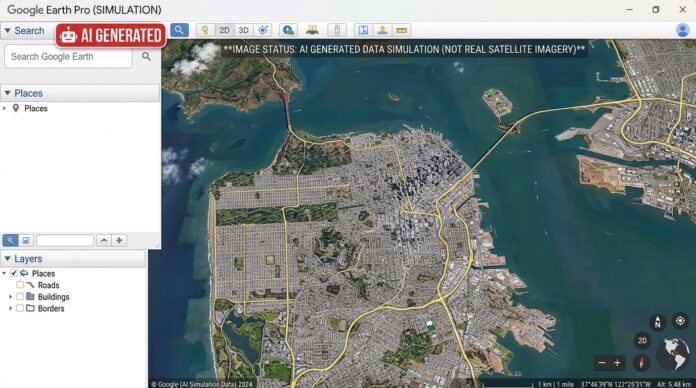
The feature ran on Nano Banana 2, Google’s latest AI image generation model, and let users type a text prompt to create photorealistic scenes layered directly onto Google Earth’s satellite, aerial and 3D imagery. In practice, that meant anyone could pick a real set of coordinates, anywhere on the planet, and generate a fabricated event there, an explosion, a flood, a military convoy, that looked as though it belonged to the platform’s existing trove of authentic imagery.
Google Earth has built its reputation over roughly two decades as a tool that journalists, researchers, emergency responders and ordinary users treat as a dependable record of what a place actually looks like. That reputation is exactly what made the new feature so contentious almost as soon as it launched.
How the risks surfaced
Open source investigator Henk van Ess, who writes about digital misinformation, was among the first to publicly demonstrate how the tool could be misused. He generated a series of fabricated images, including a nonexistent nuclear facility in Iran, an invented refugee camp along the US-Mexico border, and a fake hospital in Gaza shown with a bomb crater beside it. He described the underlying problem bluntly on his blog, arguing that Google had spent two decades building a reference the world checks against, only to add a feature that makes things up.
Researchers at Bellingcat, the open source investigations outlet, raised similar warnings, and BBC Verify, the corporation’s verification and fact checking unit, ran its own tests on the tool. Its reporters generated additional examples showing the scale of the problem: a fabricated blast crater in Los Angeles, an invented flood scene at the US Capitol, and a fire that never happened on Iran’s Kharg Island, an actual oil export terminal.
Google had built in a safeguard from the start. Every image created with the tool carried a SynthID digital watermark, an invisible marker meant to let people check whether an image had been AI generated, either through the Gemini app or through Lens in Google Search. Google pointed to that system when early concerns surfaced, saying the watermark gave anyone unsure about an image a way to verify it.
BBC Verify’s testing complicated that reassurance. Reporters found that while SynthID generally worked as intended, it was possible in some cases to bypass the check entirely, tricking Gemini into identifying a fabricated Google Earth image as authentic. Independent AI detection tools that reporters also tried failed to catch some of the generated images. A community note later attached to Google’s own statement on X made a related point, noting that the watermark only covers the portions of an image actually generated by Nano Banana, which leaves an opening for the safeguard to be worked around.
Google’s response
Google announced the suspension on July 31 in a post on X, saying it had seen people sharing screenshots of generated imagery that appeared to violate its policies. The company didn’t specify exactly which violations it had observed, but said it was pausing the feature while it worked on stronger guardrails, and that it planned to bring the tool back once those protections were in place. No timeline was given for when that might happen.
The company framed the episode partly around trust, noting in its statement that people uniquely rely on Google Earth for a reliable view of the world. That framing lines up with how the company originally pitched the feature at launch, when it said geospatial professionals had already found a range of legitimate uses for it, from urban planning concepts to historical visualization and environmental monitoring work. Google’s decision to pause the tool rather than cancel it outright suggests the company still sees value in the underlying capability, even as it works out how to prevent the kind of misuse that surfaced almost immediately.
Bill Greer, a geospatial analyst and co-founder of the nonprofit satellite imagery service Common Space, told BBC Verify that fabricated imagery embedded inside a trusted mapping platform carries a particular kind of risk, since it can undermine confidence in genuine satellite evidence more broadly. He noted that false satellite images have already turned up in past misinformation campaigns, well before this specific tool existed, which is part of why a feature that made fabrication this easy raised alarms so quickly among researchers who track this kind of content.
Part of a broader pattern
The Google Earth episode isn’t an isolated case this year. Meta pulled its own Muse Image AI feature within days of launching it in July, after criticism that it let users generate images based on public Instagram accounts without the consent of the people who owned them. Taken together, the two incidents point to a recurring issue across the AI industry: companies are shipping powerful generative features faster than they’re able to anticipate how those features might be misused once they reach the public.
For Google specifically, the stakes are arguably higher than for a typical AI image tool, precisely because Google Earth’s core value has always rested on being treated as an authoritative source. A chatbot that occasionally makes things up is one kind of problem. A mapping platform that people already trust, suddenly capable of manufacturing convincing fake satellite evidence of an event at a real location, is a different kind of problem entirely, since the whole point of satellite imagery in journalism, research and conflict monitoring is that it’s supposed to be verifiable.
Whether Google can rebuild sufficient safeguards to bring the feature back without reopening the same vulnerabilities remains an open question. The SynthID bypass that BBC Verify identified suggests that watermarking alone, at least as currently implemented, isn’t a complete answer, and that any relaunch will need to address not just whether an image is labeled as AI generated, but whether that label can reliably survive being shared, cropped or re-uploaded across the web, where most misinformation actually spreads.
For now, Nano Banana 2’s integration with Google Earth remains offline, with the company saying only that it’s working on stronger protections before it returns. Given how quickly the tool was used to generate convincing fake imagery of nuclear sites, military incursions and natural disasters in its first day of availability, any future rollout is likely to face far closer scrutiny than the original launch did.
This article was produced by the Maple Epoch Editorial Team. See our editorial standards and AI-use disclosure and editorial policy.